Around Me
Search
+
+
New Zealand
Otago
Coronet Peak
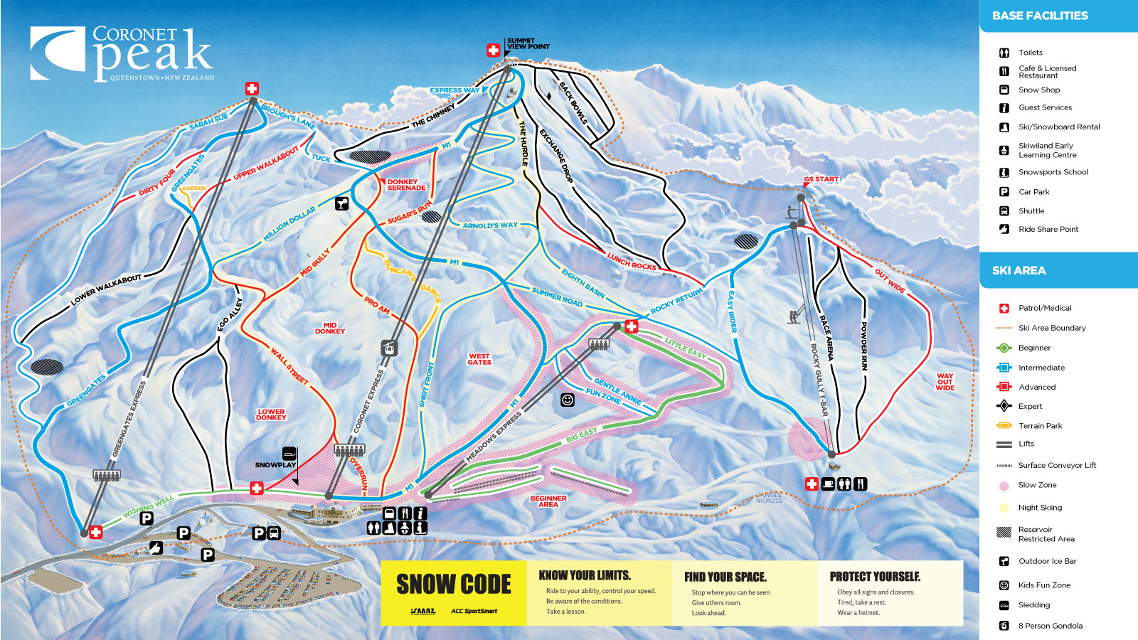
Trail Map
Coronet Peak Trail Map
Ski Resort
Reviews
Trail Map
Snow Report
Weather
Lift Ticket Prices
Home
Open Lifts & Slopes
Lift Ticket Prices
Photos
Wall
Trail Map
Interactive Map
Open Lifts
Status
Name
Beginner Carpet Conveyor
Coronet Express
Greengates Express
Kaiser Ski Conveyor
Magic Carpet Conveyor
Meadows Learner Express
Rocky Gully T-bar
Sunkid Carpet Conveyor
Advertisement
Advertisement
Lifts
8
1
3
4
Total
8
Skiable Terrain
280
ha
Easy
Green Circle
Moderate
Blue Squared
Advanced
Black Diamond
Extreme
Double Diamond
Overall Slope Area
280
ha
Number of Slopes
27
Current Conditions
Open Trails
N/A
Open Lifts
0/8
max 5
°C
Snow Upper
cm
0
Snow Lower
cm
0
Last 48h
cm
0
Detailed snow report
5-Day Weather Forecast
Ski Resorts
Ski Resort Finder
Europe
Germany
Austria
Switzerland
Italy
France
Norway
Czech Republic
Sweden
Finland
Slovakia
Poland
Spain
Slovenia
Romania
Great Britain and Northern Ireland
Greece
Netherlands
Bulgaria
Belgium
Ukraine
Serbia
Croatia
Andorra
Liechtenstein
North America
USA
Canada
Asia
Japan
China
Russia
South Korea
Turkey
Georgia
Iran
India
Azerbaijan
United Arab Emirates
Oceania
New Zealand
Australia
South America
Chile
Argentina
Africa
Egypt
Nordic Skiing
Europe
Germany
Austria
Switzerland
France
Italy
Czech Republic
Norway
Sweden
Finland
Poland
Slovakia
Slovenia
Spain
Liechtenstein
Andorra
North America
USA
Canada
Oceania
Australia
New Zealand
South America
Argentina
Chile
Asia
Russia
Lodging
Europe
Austria
Switzerland
Germany
Italy
France
Czech Republic
Poland
Liechtenstein
Finland
North America
USA
Canada
Oceania
Australia
New Zealand
Magazine
News
Top 10
Specials
Equipment
World Cup
Inside
Tips & Tricks
Ski Reviews
Skis
Ski Finder
Sort by category
All Mountain Ski
All-Rounder
Powder Ski
Junior Ski
Kids' Ski
Race Inspired
Race Ski
Sport Carver
Slalom Ski
Misc. Ski
Backcountry Touring Ski
Twin-Tip / Freestyle
Lady Ski
Sort by brand
Völkl
Atomic
Rossignol
Fischer
Elan
Dynastar
Blizzard
Salomon
Head
K2
Nordica
Stöckli
Kästle
Scott
Movement
Armada
Line
Black Diamond
Amplid
Indigo
Hagan
Zag
Bogner
Bohême
Vist
Surface
CoreUPT
4FRNT
Lacroix
Icelantic
DPS
Mountain Wave
German
This website uses Cookies to ensure you get the best experience on our website
Data Protection Regulations
I got it
Ski Resort Finder
Ski Finder
Sweepstakes
Packages & Deals
Snow Ticker
Map
Login
E-Mail
Password
Login
Forgot your password?
Create new account